In a nutshell
Gauge: 2'
Length: Approx ¾ mile overall
Opened: Originally mid 19th century
Visitor tramway - early 1970s
Location:
Morwellham Quay
Morwellham
Tavistock
Devon
PL19 8JL
United Kingdom
Web: admin@morwellhamquay.org
https://www.morwellham-quay.co.uk/
Date of visit: 9 June 2015
Key Facts
- Morwellham Quay was established in at least 1105 and remained important as a harbour well into the 19th century when it became the biggest exporter of copper in the British Empire with vessels of up to 300 tonnes using the quays.
- The George and Charlotte copper mine through which the railway runs was opened in 1718 when it was known as the Providence Mine. The George and Charlotte Mine is first mentioned in documentary sources from 1775.
- The tramway runs 460 metres into the Deep Adit of the mine and passed an underground waterwheel which was used to pump water out of the lower levels of the mine 350 feet below.
- In addition to copper and arsenic, the mine yielded a number of rare minerals including the largest known crystals of childrenite in the world.
- Between 1862 and 1867 the mine reached its peak production, but it closed in 1868. It was reopened from 1869 to 1871.
- In the early 1970s, a new access to Footway Shaft was created to allow the narrow gauge tramway to be constructed. The railway travels for over 480 metres into the mine.
- The railway follows the entrance to Deep Adit, just above the River Tamar, and extends past Whim Shaft, an internal shaft, the bottom of Crosscourse Shaft, and past Ley's Shaft towards Downs Shaft.
- This adit was the main water drain for the mine and also the principal means of access for materials.
- The adit roof is approximately 2 metres high and 1.8 metres wide.
- In 1985/86 the 'New Quay Drive' railway tunnel excavation (through virgin rock) connected the side of Deep Adit (at a point approximately 200 metres from the portal) to a new railway tunnel portal, via Engine Shaft thereby making a balloon loop for the railway.
- The railway uses battery powered locomotives and specially built 'carriages' for the visitors.
Route
My Impressions
After parking and making my way through the ticket office and shop for the Morwellham Quay site, I made my way down towards the quays and the main exhibits

The site itself looked very interesting but I was anxious to make my way directly to the Mine Tramway as I heard it can become very busy at peak times. After passing through the main village, I headed upwards behind the white buildings on the right to the Mine Tramway station.

A small queue was forming and we had to wait as a party of French schoolchildren were pre-booked on to first train.

Before long another train pulled into the station ......

.... and before boarding there was a brief opportunity to admire the one of the BEVs (Battery Electric Vehicles) which would be our motive power for the journey underground.

We were ushered aboard the passenger coaches and given safety instructions. I managed to secure a place directly behind the loco - an advantage of getting there promptly and waiting .....

....... and before long we were off. The first quarter of a mile or so of track took us alongside the River Tamar which we glimpsed from time to time through the trees and bushes which lined the railway ......

..... and then we reached the entrance to the mine itself - which looked quite unprepossessing and utilitarian.

The train wound its way through various galleries and tunnels where clearances were quite tight - which explains the cage-like structure surrounding each carriage.

At intervals we stopped and our driver informed us about the history and working practices in the mine.

The conditions were harsh and much of the work was done by hand. It seems hard to believe that, at one point, this mine and those surrounding it were the most productive in the whole of the British Empire.

After negotiating a few more twists and turns, we came to what was, for me, the highlight of the tour .... the underground waterwheel.

Not easy to photograph through the grille of the carriage roof, the waterwheel, which has been restored to working-order, was used to pump water from the lower chambers of the mine, which extended up to 350 feet below us.

We then set forth one more ........

..... until, ultimately, daylight was seen once more.

We emerged into outside world and made our way to a run round loop, ........

..... which gave us some tantalising glimpses of yet more industrial archaeological sites beside the river.

The loco ran around its train ......

..... and we then made our way back up the valley ....

..... passing en route, the entrance to the mine which we used previously.

We now retraced our tracks .....
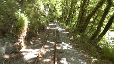
...... before arriving at the station once more.

There was time to watch the loco run round its train .....


..... before it made ready for the next batch of visitors.
There was time for me to visit a few more of the exhibits .....

.... including the house which had been used for the filming of the TV documentary about the Edwardian Farm.

I was very impressed with the mine tramway. It afforded us with the opportunity to venture into the workings of a real copper mine and gain some idea of the sorts of conditions in which this important ore was extracted during the Victorian era.
I thoroughly enjoyed my visit - not only to the railway - but also to the whole site - and the corned beef hash which I enjoyed in the café
was also something to savour.

The site itself looked very interesting but I was anxious to make my way directly to the Mine Tramway as I heard it can become very busy at peak times. After passing through the main village, I headed upwards behind the white buildings on the right to the Mine Tramway station.

A small queue was forming and we had to wait as a party of French schoolchildren were pre-booked on to first train.

Before long another train pulled into the station ......

.... and before boarding there was a brief opportunity to admire the one of the BEVs (Battery Electric Vehicles) which would be our motive power for the journey underground.

We were ushered aboard the passenger coaches and given safety instructions. I managed to secure a place directly behind the loco - an advantage of getting there promptly and waiting .....

....... and before long we were off. The first quarter of a mile or so of track took us alongside the River Tamar which we glimpsed from time to time through the trees and bushes which lined the railway ......

..... and then we reached the entrance to the mine itself - which looked quite unprepossessing and utilitarian.


At intervals we stopped and our driver informed us about the history and working practices in the mine.

The conditions were harsh and much of the work was done by hand. It seems hard to believe that, at one point, this mine and those surrounding it were the most productive in the whole of the British Empire.

After negotiating a few more twists and turns, we came to what was, for me, the highlight of the tour .... the underground waterwheel.

Not easy to photograph through the grille of the carriage roof, the waterwheel, which has been restored to working-order, was used to pump water from the lower chambers of the mine, which extended up to 350 feet below us.

We then set forth one more ........

..... until, ultimately, daylight was seen once more.

We emerged into outside world and made our way to a run round loop, ........

..... which gave us some tantalising glimpses of yet more industrial archaeological sites beside the river.

The loco ran around its train ......

..... and we then made our way back up the valley ....

..... passing en route, the entrance to the mine which we used previously.

We now retraced our tracks .....

...... before arriving at the station once more.

There was time to watch the loco run round its train .....


..... before it made ready for the next batch of visitors.
There was time for me to visit a few more of the exhibits .....

.... including the house which had been used for the filming of the TV documentary about the Edwardian Farm.

I was very impressed with the mine tramway. It afforded us with the opportunity to venture into the workings of a real copper mine and gain some idea of the sorts of conditions in which this important ore was extracted during the Victorian era.
I thoroughly enjoyed my visit - not only to the railway - but also to the whole site - and the corned beef hash which I enjoyed in the café
was also something to savour.
Video


