The railway is built on the trackbed of the former standard gauge railway from Wroxham to Aylsham in Norfolk
A footpath/cyclepath runs alongside the railway for its entire length
The railway regards itself as narrow gauge rather than miniature
It has five steam locomotives - four of which are based on the Indian Railways ZB class of locomotive (one has been modelled on a Vale of Rheidol loco and another resembles a Leek & Manifold loco). The fifth loco started life as a diesel locomotive and has operated on a range of railways across the country. It was converted to steam power when it joined the Bure Valley in 1991
The railway possesses three diesel locomotives
The station at Aylsham includes a cafe, a model railway shop and sells souvenirs. There is also a shop run by volunteers which sells secondhand books and memorabilia.
I arrived at the Aylsham Station in the late afternoon on a Sunday and was in time for the penultimate service of the day - the last steam-hauled service. I had half an hour to kill and so treated myself to coffee and cake in the Whistlestop café ..........
......... and had time to browse through the books in the volunteers' shop ...........
.......... and view the model railway stuff and souvenirs in the shop where I also bought my ticket for the journey.
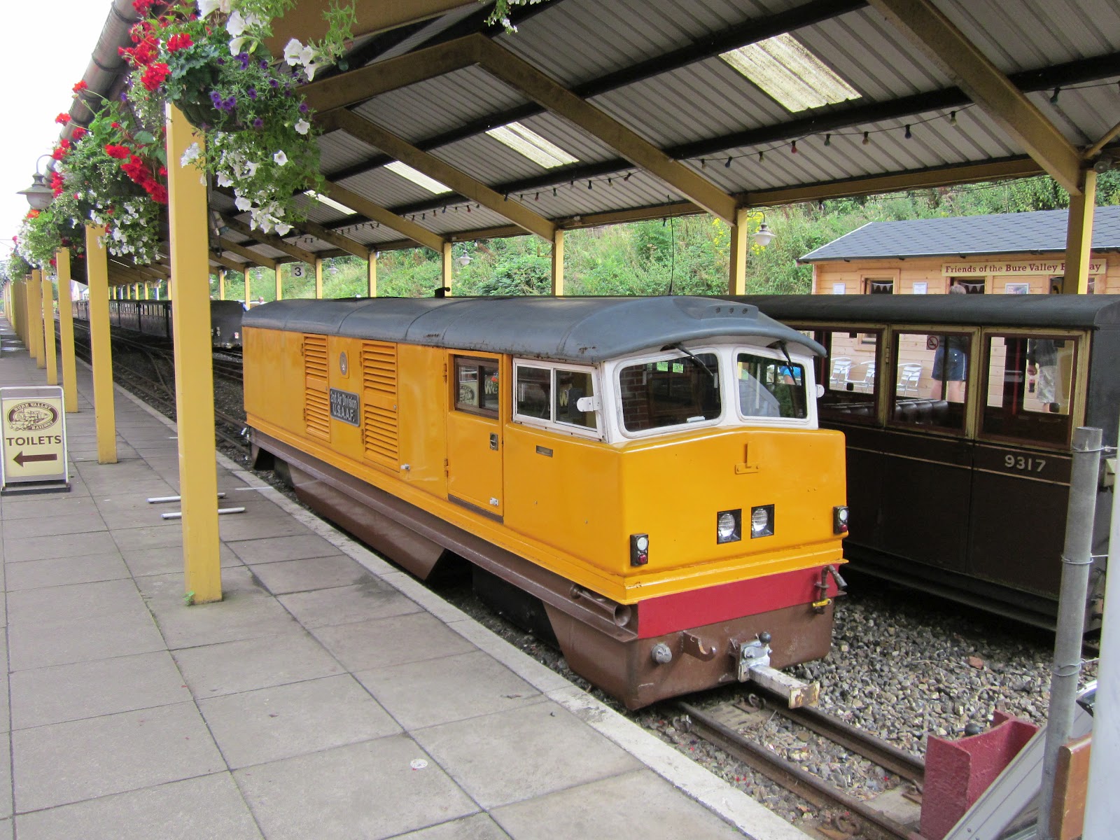
The train-shed at the station is quite impressive, giving the railway an air of importance. At the end of Platform 2 was the line's principal diesel hydraulic loco, "2nd Air Division USAAF" so-named to commemorate the B24 Liberator bomber crews who flew out of Norfolk's airfields during WW II.
With the other passengers, I made my way to Platform 3 where 2-6-2
locomotive "Spitfire" was waiting to haul the train to Wroxham.
The 15" locos on the Bure Valley are impressive machines, well matched to hauling their trains at quite impressive speeds along the nine mile route.
Before long the whistle sounded and we were off. For almost the entire journey a footpath/cycle path shares route of the railway.
The train bowled along at what seemed like a remarkable speed, exaggerated by the closeness to the ground and by the clickety-clack of the wheels over the rail-joints. Within a short while we pulled into Brampton Station, though we didn't stop on this occasion as there were no passengers to be picked-up or dropped-off.
Further along the line we arrived at Buxton where we dropped off a couple of passengers.
We crossed the River Bure on a girder bridge which also includes a footbridge for walkers and cyclists.
We soon rolled into the passing loop which marks the midway point of the railway where we awaited the arrival of the Up train, hauled by "Spitfire's" sister locomotive, 2-6-2 "Blickling Hall".
After a short while we reached Coltishall Station near the site of the WWII airfield which was the base for the Spitfire 124 Squadron after which our locomotive was named. It was also the base at which the legless air ace Douglas Bader was based earlier in the war.
At Wroxham we had twenty minutes while the loco was turned .........
....... in preparation for the return journey.
The final train of the day which we passed at the midway point was hauled by the line's diesel.
Before long, we passed through the line's tunnel before arriving back at the terminus in Aylsham.
As the day was coming to a close, I was able to do some trainspotting ad the end of the platform as the steam locos were being refuelled and stabled for the night.
The workshops are open to visitors and so, with the distinctive smell of steam oil and coal smoke in the air I reluctantly departed from this fascinating little railway.
Despite its diminutive size, the railway is run in a highly professional manner. I found all the staff to be helpful and devoted to their work which is hardly surprising considering the attractiveness of the railway and its environs. One day, I will return to take some trackside shots.
The railway was 3' gauge - despite the plaque (see below) two other English passenger carrying railways adopted this gauge (the Rye & Camber and the original Ravenglass and Eskdale) as well as several industrial railways (and the Isle of Man Railways).
The major engineering work on the line was a 146' swing bridge over the River Blyth near Walberswick
The railway had three 2-4-0T locomotives when it opened constructed by Sharp Stewart (Southwold, Halesworth and Blyth), later Southwold was exchanged for a 2-4-2 loco, also called Southwold.
The line was extended to Southwold Harbour in 1914 and a larger 0-6-2 Manning Wardle locomotive (Wenhaston) was purchased to handle the anticipated increase in traffic
The railway was single-line throughout and operated on the principle of one locomotive in steam. A simple signalling system was also in operation using combined home and starter signals on the same post.
I have been visiting Southwold since the mid 1980s and over the years have traced most of the railway's former route. Although I have accumulated a number of photos I have not formerly been systematic in my deliberations. For this first blog-related visit I started at Southwold.
My first port of call was the Southwold Railway Trust shop in Southwold .........
.... where I got up to speed with the latest developments in the Trust's plans to build a heritage centre for the railway (the fourth proposal). The architect's model of the proposed visitor centre at Wenhaston has been very well thought-through, though time will tell whether local objections will scupper this latest plan.
Next, I wandered down to the site of the former station at Southwold, now housing a fire station, a police station and some private housing.
The plaque on the wall of the police station building indicates the position of the station yard and suggests the Southwold was the only 3 foot gauge railway in the country (see above).
This photo of Southwold Railway Station was taken in the 1890s, shortly after the railway opened.
It's not possible to now take a similar photo as this would involve tramping around the gardens of private houses. The edge of the former Station Hotel is just visible in the background.
A closer view of the hotel (now called the Blyth Hotel)
This photo taken further along the railway shows the hotel under construction in around 1900
This shows the scene as it is today. Allotments now cover the land to the left but the unmade road on the right is more or less in the same position as it was when the railway was in operation
This postcard shows the same scene from a slight different position. The railway's signalling system can be seen clearly in these two images - combined starter and home signals on the same post. In this view two sets of signals can be made out - inner and outer homes and starter and advanced starter.
I next ventured down to the harbour where a short length of rail and a buffer-stop can still be discerned along the former quayside.
Behind the quayside buildings it's just possible to make out the trackbed of the link between the harbour and the mainline snaking across the water meadows.
A short walk along the banks of the River Blyth and I came to the site of the swing bridge over the river. Looking towards Southwold in 1938, the distinctive water tower can be seen on the skyline.
Today's view from the Southwold end of the bridge shows the route of the railway curving away towards the golf course cutting. This footpath/cycleway links to the unmade road beside the site of the station as shown above.
The stanchions for the swing bridge are now used to support a footbridge taking the footpath over the river.
This contemporary photo shows the Walberswick end of the bridge (the second erected on this site). The bridge was widened when plans were proposed to change the railway to standard gauge.
It is possible to continue the walk along the trackbed across the common towards Tinkers Covert and the Heronry..........
......... but on this occasion time was tight and so, reluctantly I had to turn back. I hopped back in the car and drove up to Blythburgh where it's possible to park on the site of the station which now houses recycling bins for the locality.
The railway bridge under the A12 has long been dismantled but the concrete base of the station building is still visible ......
..... and at the other end of the station site, the dilapidated coal shed is still extant.
No one is quite sure as to why coal was stored in sheds on the Southwold railway - one can only assume it was felt coal would be safer kept under lock and key! It is possible here to walk along the trackbed as it winds its way around the impressive church, but once more I hopped into the car and headed off towards Wenhaston village.
The site of the station is marked by a small memorial but the rest of the site is now occupied by the garden of a private house.
As can be seen, the station building was very close to the road, which was crossed by a level crossing......
The abutments for the stream bridge can still be seen on the opposite side of the road from the memorial ......
...... and the field beside the former station site is where the proposed visitor centre could be sited. Planning permission has been sought and the outcome of the planning committee's deliberations are due in mid September.
It's not possible to walk the trackbed here as it lies on private property and so, back into the car and off to Halesworth. On entering Halesworth from Holton Road, it's possible to make out one of the abutments for the Southwold Railway beside the standard gauge railway bridge.
The mainline railway station now houses a museum for the area, including some exhibits related to the railway. Walking along the platform it's possible to see the swinging section of the platform which once bridged the main road level crossing.
In the same position we can see that the bank is still there but the site of the platform is now an access road for a housing estate.
Looking back the other way, on the right is the site of the old Co-op dairy, in the centre is where the interchange shed for the railway was located and on the right is what was the East Suffolk mainline railway to Beccles - now reduced to a single-track branchline.
In this early picture of the station at Halesworth, taken from near the same position as the photo above, the chestnut tree in the foreground is little more than a sapling. In later photos of the station (as above) it has grown into a mature tree.
There is now very little evidence of the Southwold Railway station at Halesworth but, with a little imagination it's possible to visualise the bustle as GER trains arrived and disgorged passengers to cross the footbridge which led to the Southwold platform.
I shall certainly be revisiting the Southwold Railway - hopefully to ride upon the replica of one of the diminutive Sharp Stewart locomotives which is currently being constructed by the Southwold Railway Trust and also to walk some of the stretches of the old trackbed which are still accessible. An excellent walking guide is available from the SRT shop which provides an annotated tour of the route of the railway showing where access can be gained and what remains of what for me is one of the most captivating and fascinating narrow gauge railways in the country.


