Search This Blog

Showing posts with label preservation. Show all posts

Tuesday, 21 May 2013

Corris Railway

In a nutshell

Gauge:         2' 3"


Length:       Originally = 6½ miles
                     Preserved railway = ¾ mile


History:      1858 - horsedrawn tramway from Aberllefenni to Derwenlas Quay opened
                    1864 - line from Machynlleth to the quay at Derwenlas closed
                    1878 - steam locomotives and passenger services introduced                   
                    1929 - line acquired by GWR
                    1931 - passenger services removed
                    1948 - railway closed and stock scrapped or sold off
                    1966 - Preservation Society established
                    1970 - Museum opened
                    1985 - First preserved train ran

Location:


View Narrow Gauge Railways in a larger map


Date of visit:  6 May 2013


Key Facts

  • The railway ran for most of its length beside the road up the valley from Machynlleth to Corris with a steady gradient of around 1:40
  • The railway was originally constructed to transport slate from the quarries around Corris and Aberllefenni to a wharf on the River Dovey to the west of Machynlleth
  • When the Cambrian mainline reached Machynlleth, the line from Machynlleth to the wharf was closed and the slate traffic was instead transferred to standard gauge wagons
  • In 1878 the railway acquired three steam locomotives and ten four wheeled passenger carriages, though passenger services were suspended until 1883 owing to a dispute with local quarry owners
  • The Great Western Railway acquired the line in 1927 and shortly afterwards suspended passenger services
  • When the railway bridge over the River Dovey near to Machynlleth was weakened by floods in 1947, it was decided that it was uneconomic to continue running the line
  • The railway was one of the first to be closed by the newly nationalised British Railways
  • In 1966 a small group of Talyllyn Railway members formed the Corris Railway Preservation Society and acquired the station buildings and yard in Corris
  • The museum and a short length of track was opened in 1970-71
  • In 1981, the railway acquired the engine shed at Maespoeth and shortly afterwards the line was relaid from Maespoeth to Corris although for various bureaucratic reasons it was not possible to re-establish passenger services until 2002
  • There are plans to extend the railway from Maespoeth for 2½ miles down the valley to Tan-y-Coed and eventually to Machynlleth

Route

Original route - source: wikimedia
The railway today - source: http://www.corris.co.uk


My Impressions

When I arrived at the station yard in Corris, a train was in the station and about to depart for Maesporth. On this occasion only one coach was in use as the line's other carriage was in the sheds awaiting repair.

The coaches are replicas of the railway's original coaches which were in fact made from the bodies of two four wheel coaches mounted on a chassis with bogies.

I boarded the train with the twelve other passengers and the line's steam locomotive, a faithful replica of one of the railway's original Tattoo class locomotives, began its sedate journey down the ¾ mile to the line's workshops and sheds at Maespoeth.

 This was the site of the junction where the line divided to serve the quarries at Corris Uschaf and Aberllefenni.

We were given a guided tour of the workshops. In the carriage shed, the lines other coach was under repair, another was under construction and some goods stock was in the process of being renovated.

 After an enlightening talk about the history of the railway and its subsequent preservation, we made our way up to the station yard, where a new platform is under construction and one of the line's diesel locos was pottering around shunting wagons loaded with building materials and sleepers.

The signal cabin which controls the station area is not a replica of the original but has been constructed on-site by the Society.

 Once the line has been extended further down the valley, the signal box will perform an essential function monitoring and controlling the movement of trains through the station.
Maespoeth Junction signal diagram - Source: http://www.256.eclipse.co.uk/tube/MaespoethDiag.jpg
We then had an opportunity to view the engine shed which is one of the railway's original structures. It has recently been re-roofed and still retains many of its original features, including a large slate water tank.

After wandering around and viewing more of the station area, we wandered back to the platform, taking in a glimpse of the track winding back up the valley to Corris.

There was a quick opportunity to take a few more pictures of the our train.......

....before re-boarding for the return journey. As there are presently no operational run-round facilities at either station, the train operates as a shuttle. We were sedately propelled up the line to Corris where there was an opportunity to view the line's museum and shop.

In addition to railway artefacts, there are some fine models of various parts of the original railway on display.
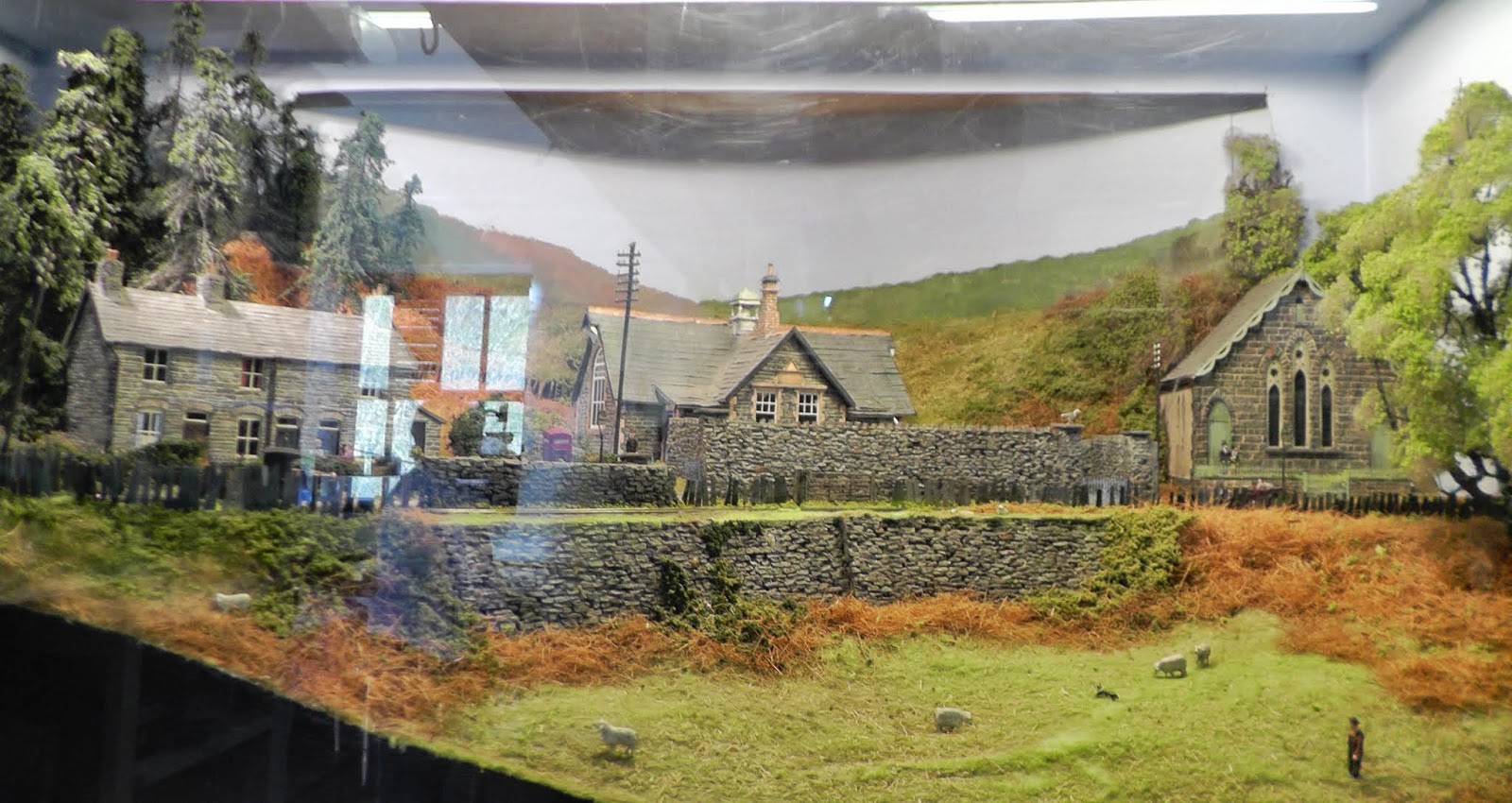
 After partaking of a freshly made cup of tea, I explored the immediate locality, finding the street modelled in the above photo.......

.... and discovering that as the railway continued its way through the village and onwards towards Aberllefenni, it passed very close behind the houses, which have now adopted the route of the railway to provide some much needed backyard psace and/or extensions.


One day I will return to walk the route of the line, documenting what remains of the trackbed, but on this occasion, I took a lingering look up route of the railway towards Aberllefenni ......

....... before walking back through the village towards the station, passing on the way the bridge over the stream which has now become a patio area for the neighbouring house.

I then followed the route of the existing railway ..........

.... taking the opportunity to get some lineside shots as the train made its way down to Maespoeth .......
 

..... and then back up the line to Corris. 

As this was the last train of the day, I returned to my car in the station's car park and then made my way back home.

I found the Corris Railway to be a very friendly place. The staff were clearly (and rightly) proud of their achievements and more than willing to answer even the most naive of my questions and also to provide plenty of additional information. It seems they have plans to remodel Corris Station, including a rebuild of the train-shed which was a feature of the stations at both Corris and Machynlleth. The planned extension will be the next phase in their ambition to restore the line to Machynlleth, which is readily achievable as much of the trackbed is still in existence, though road widening has, in some places, encroached on the route of the railway.

Although the museum and shop are quite small, the welcome is large and there are plenty of secondhand books and DVDs to satisfy the enthusiast whose sales will help to swell the society's funds. There are light refreshments and hot drinks available and an opportunity to discuss the railway's past, present and future with the staff as you sit and sup.

One advantage of a compact railway such as this is that can be visited in around an hour (or longer if you want to explore further aspects). And so, it caters well for those who want to drop in on their way through the valley. I would strongly urge you to do so whenever you are in the area. Such an interesting and unique narrow gauge railway is well worth the visit.

Virtual Visit Video


Monday, 14 January 2013

Lynton & Barnstaple Railway

Source: http://trainweb.org/railwest/images/stn/chelfham-1.jpg

In a nutshell

Gauge:   1' 11½"

Length: 19 miles 23 yds (0.9 miles now preserved)

Opened: 16th May 1898 (Closed 29 September 1935)

Location:


View Narrow gauge railways Britain & Ireland (closed) in a larger map Web:   


Date of visit: 13th January 2013


Key Facts

  • The railway was opened in 1898 following enthusiastic and material support from local landowner and publisher, Sir George Newnes.
  • There were three stations in Barnstaple. The Lynton & Barnstaple Railway started alongside Barnstaple Town Station which was on the L&SWR Ilfracombe branch line
  • The railway followed the contours of the countryside through which it was built and for much of its length maintained a gradient of 1:50
  • There were 6 stations (Barnstaple Town, Chelfam, Bratton Fleming, Blackmoor, Woody Bay and Lynton & Lynmouth), three halts (Snapper, Parracombe, and Caffyns) and one goods yard (Pilton) along the line.
  • There were 80 bridges over and under the line, the most spectacular of which is the 70 foot high, eight span, Chelfam viaduct which is largest narrow gauge railway structure in the British Isles.
  •  The line had three 2-6-2 Manning Wardle tank locomotives - Exe, Taw and Yeo and a Baldwin 2-4-2T locomotive, Lyn, of a similar design. A fifth Manning Wardle locomotive, Lew, was purchased in 1925.
  • The railway was absorbed into the Southern Railway in 1923 and the locomotives and rolling stock were repainted in SR livery.
  • Much of the trackbed is still in existence, the preservation society (The Lynton and Barnstaple Railway Trust) is in the process of restoring the railway and has relaid 0.9miles of track at Woody Bay. It has also purchased some key features along the line (eg Snapper Halt) and some isolated sections of the trackbed. The plan is to rebuild the majority of the railway in phases. However, four of the stations are presently in private ownership.

Route

Source: http://upload.wikimedia.org/wikipedia/commons/thumb/8/8d/L%26bmapimage.jpg/600px-L%26bmapimage.jpg

My Impressions

This was my first visit to the route of the Lynton & Barnstaple Railway and, as I was in the area for a family event I had only a half day to spare for this initial exploration.

I began my tour of the line by firstly finding the location for line's terminus beside the River Taw in Barnstaple. The station building is still in existence and currently in use as a community centre..

Source: http://www.disused-stations.org.uk/b/batnstaple_town/barnstaple_town_old(alsop9.1967)7.jpg
The yard has now become a public car park adjacent to the town's civic centre and police HQ......

.... and a block of flats has been built where the platform once stood.

Source: http://sphotos-b.ak.fbcdn.net/hphotos-ak-ash3/541715_10200209064449935_1352781858_n.jpg
Source: http://www.disused-stations.org.uk/b/batnstaple_town/barnstaple_town_old(alsop_early20thc)2.jpg

By walking across the car park, I was able to follow the route of the line is it curved to the right alongside the River Yeo, making my way towards the Braunton Bridge.....

 ...... where there was once a level crossing (the railway can be seen curving up towards the centre of this picture)
Source: http://www.explorenorthdevon.org/Images/band/BA437.jpg
Crossing the Braunton Road and looking back, the warehouse beside the wharf is still in existence.......
Source: http://www.trainweb.org/railwest/images/lc/~braunton-rd.jpg
A short walk beside the river followed by a quick a hop across Pilton Causeway (formerly Pilton Road) and I found the entrance to the Pilton Yard is still evident with the caps for the gate posts now mounted on brick pillars.

Source: http://lynton-rail.co.uk/files/images/pilton1930.jpg
As with the station, the yard is now a car park but it is possible to identify some of the features shown in some of the contemporary pictures of the railway. For example, the house-backs beside the yard......
Source: http://www.009.cd2.com/albums/lynbarn/images/16m.jpg

 .... and although the carriage and loco sheds have disappeared, the brick built offices for the original railway are still to be found. The L&B Railway Trust proposes to use these as a museum if they manage to acquire them.
Source: http://www.009.cd2.com/albums/lynbarn/images/62.jpg
With Ordnance Survey Explorer Map OL9 in hand, I returned to my car and set off up the Goodleigh Road to see which other landmarks I could identify. I was unable to find a suitable parking spot near to Snapper Halt but a little further along the road I was able to stop near to Collard Bridge.........
 ....... from which the trackbed leading back towards the site of the bridge across the River Yeo was clearly discernible.

Source: http://www.009.cd2.com/lynton_and_barnstaple_modelling/images/6m.jpg
A short drive and the impressive Chelfam viaduct loomed into view. I parked in its shadow and took a few pictures.......
Source: http://www.009.cd2.com/albums/lynbarn/images/9m.jpg

...... before following the signs and venturing up the hill to Chelfam station ...........
Source: http://www.009.cd2.com/albums/lynbarn/images/68.jpg
....... which is now owned by the L&B Community Interest Company, the trading subsidiary of the L&B Railway Trust.
Source: http://www.009.cd2.com/albums/lynbarn/images/28.jpg
I was fortunate to be treated to a tour of the building and the site by one of the volunteers, Nigel Thompson, who filled me in on the latest developments and plans for developing the line further. I was very impressed by the enthusiasm and dedication shown by this band of stalwarts in rescuing what is considered by many to be the country's most picturesque narrow gauge railway.

In the building (which will shortly be restored to its original state) are a couple of fine 4mm scale models of the the railway as it was. A representation of Lynton Station .......

.... and one which was inspired by Chelfam.........

.... and the viaduct.

In the station yard, there was plenty to see, including the original signal cabin .......

...... and an accumulation of railwayana and equipment,
Source: http://www.009.cd2.com/albums/lynbarn/images/26.jpg
...... some of which is original such as this concrete signal post which they are planning to return to its former position at the north end of the station .......

With a last tantalising glimpse of the viaduct from the station yard........
Source: http://www.009.cd2.com/albums/lynbarn/images/87.jpg
 ..... and with the sun beginning to set in the winter sky, I once more hopped into my vehicle to resume my exploration of the railway's route.

I followed the road to Bratton Fleming, where I turned off towards Rye Park to find the station which was to the north of and below the village. The station site is now privately owned but the former station yard could be seen from the overbridge ........
Source: http://www.009.cd2.com/albums/bratton/4.html
Source: http://www.009.cd2.com/albums/lynbarn/images/59.jpg
.... while to the north, the cutting now seems to house an intriguing length of contractor's track. Apparently, there was recently a private 7¼" railway here which ran a replica of a L&B loco.

 Following a tortuous single track country lane I once more encountered the trackbed for the railway near Narracott. When I had been plotting the route for the railway on Google Maps (see above) I became confused because the trackbed seemed to disappear. Eventually, the only explanation I could reach was that a present-day road had adopted the trackbed. This was confirmed when I encountered the remains of Narracott overbridge...........

........ which was  directly opposite an enticing stretch of road (Twitchen Lane - see below) which could only have been the railway.

The road wound on for a mile or so in cuttings and on embankments with plenty of concrete fencing posts on either side which I assumed dated back to the 1920s.
The last down train approaching Blackmoor on 29 Sept 1935 Source: http://www.009.cd2.com/albums/lynbarn/images/10m.jpg
Further north, the trackbed has been submerged under Wistlandpound Reservoir but for my flying visit my next port of call was the site of Blackmoor Station which now houses a restaurant.

The distinctive shape of the station building was still visible

Source: http://www.halsgrove.com/prodimages/ingdlge.gif
...... and the base of the old water tower has now been converted to a substantial shed, though the pipework is still very much in evidence. The overbridge has been removed but on the other side of the road, beside the Exmoor Park car park, the remains of the cutting can still be made out.
Source: http://www.009.cd2.com/bratton_fleming/images2/2.jpg
Source: http://www.009.cd2.com/albums/lynbarn/images/32.jpg
 I caught occasional glimpses of the railway trackbed on the road towards Parracombe and stopped off at the Rowley Cross picnic site which has been set up by the L&B Railway Trust beside the Parracombe Embankment.
Source: http://www.009.cd2.com/albums/lynbarn/images/34.jpg
If I'd had more time I would have explored Parracombe but I spent a short while at Woody Bay which was closed for the winter period. However, there was plenty on view to whet the appetite for a return visit.
Source: http://www.009.cd2.com/albums/lynbarn/images/33.jpg
Source: http://upload.wikimedia.org/wikipedia/commons/a/a6/L%26Bwoodybay.jpg
Source: http://www.009.cd2.com/albums/lynbarn/images/65.jpg
 My final destination had to be Lynton, the northern terminus for the railway. Perched on the hillside above Lynmouth,
Source: http://www.visitlyntonandlynmouth.com/sites/default/files/styles/large/public/lynton-station_0.jpg
....... the station building is now a private residence
Source: http://upload.wikimedia.org/wikipedia/commons/0/04/Lynton_%26_Lynmouth_Station_2026541_98af1955.jpg
..... and the goods shed has been converted into two cottages.
Source: http://www.oldpicturepostcards.co.uk/lyntonrailway.jpg
 The railway clearly richly deserves the reputation it has accumulated over the years and this little taster has provided me with plenty of incentive to make a return visit in the summer season when it will be possible to take a ride on the preserved section of the line at Woody Bay.
Source: http://upload.wikimedia.org/wikipedia/commons/3/31/L%26Blynton.jpg

 There is also still plenty of the trackbed which I've not yet been able to see which should be accessible from footpaths.
Source: http://www.009.cd2.com/albums/lynbarn/images/29.jpg
I will also follow with interest, developments on the preservation society's plans to extend the line which seem to be ambitious and yet realistic, given the progress they have made so far in acquiring sections of the trackbed.

For more information on the Railway Trust's proposals see - http://www.lynton-rail.co.uk/trust

By the way, all the roads I travelled along on this trip are available in Google Street View, including the stretch of railway which has now become a road (Twitchen Lane, Narracott)

View Larger Map

Click on the image and then use keyboard arrow keys to move forward, back and to rotate left or right

The site of Parracombe Halt showing the remains of the station shelter and the parapets of the bridge in the distance:

View Larger Map

Source: http://farm5.staticflickr.com/4042/4291441682_49f4425680_b.jpg
Source: http://www.009.cd2.com/lynton_and_barnstaple_modelling/images/19m.jpg
 In the meantime, I hope you find these video clips as interesting as I have done....

Videos